Coordinate positioning
|
Besides the intrinsic and the linear track-referenced coordinate system, the RailTopoModel also allows to locate railway infrastructure elements using geodetic and geometric coordinate systems. The most known example in this case is the World Geodetic System WGS84. The same infrastructure elements can be located with multiple coordinate systems, their correspondence being established in the model.

Geometric Coordinates (© RFF/SNCF Réseau)

General
Geometric coordinates
A geometric coordinate system can either be a projected X, Y, Z coordinate system, or a λ, ϕ, h geodetic coordinate system, or even an X, Y(, Z) schematic plan coordinate system.
It could be read as "at coordinate X, Y, Z in the system [EPSG:xxxxx] [01/06/2014]4" [4: The exact content of the definition string of the geometric system is not yet final]
Linear coordinates
The model integrates a link between the linear positioning system and the intrinsic positioning system. It supports the "conversion" of an element position associated with a number between 0 and 1 to a kilometric point on its reference system.
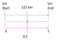
Conversion Board (© RFF/SNCF Réseau)

EPSG Code
As there are a number of different coordinate reference systems with different parameter sets available, it is important to identify the coordinate system without ambiguity. The International Association of Oil & Gas Producers set up the EPSG [1] Geodetic Parameter Registry, which provides a unique code for every coordinate system. The websites http://spatialreference.org/ and http://www.epsg-registry.org/ can be used to obtain an overview about different coordinate systems by their EPSG code.
Examples
- EPSG code for World Geodetic System WGS84: urn:ogc:def:crs:EPSG::4326
- EPSG code for ETRS89 / ETRS-TM32: urn:ogc:def:crs:EPSG::3044
- EPSG code for the height coordinate system DHHN92: urn:ogc:def:crs:EPSG::5783
Relevant classes in the RTM
The classes, used to define the location and positioning systems and their coordinates, are:
- PositioningSystem: This class defines the general concept of a Coordinate Reference System used for positioning.
- LinearPositioningSystem: This class defines a Linear Referencing System. It defines a start and an end coordinate.
- LinearAnchorPoints: this class describes the reference points within the linear reference system (Milestones, anomaly points...) and their characteristics.
- LinearCoordinate: This class defines the localization expressed in a Linear Reference System (LRS).
- GeometricPositioningSystem: This class defines a Geometrical Reference System, so it allows to locate a resource with its geometrical coordinates (x, y, z or λ, ϕ, h). The class provides the parameter crsDefinition to define the Coordinate Reference System. This parameter shall be used to name the EPSG code and thus define all the relevant parameters of the coordinate system.
- GeometricCoordinate: This class defines the localization expressed in a geometrical (or geographical) Reference System, so it defines the coordinates (x, y, z or λ, ϕ, h).
- PositioningSystemCoordinate: This class represents a coordinate in either a geometric or linear reference system.
- IntrinsicCoordinate: This class allows associating an intrinsic coordinate coming from the topology network to another coordinate, either geographic or linear.
- AssociatedPositioningSystem: This class allows to group couples of coordinates to define the translation parameters between an external (geometric or linear) coordinate system and the element’s intrinsic coordinate system.
What you should have learned
|
| Back To | Previous Chapter | Next Chapter |
|---|---|---|
| Positioning | - | Track-referred positioning |
- ↑ European Petroleum Survey Group